
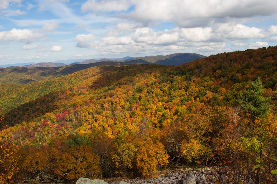
Fall in Shenandoah National Park transforms the 105-mile Skyline Drive into one of Virginia’s most stunning scenic routes. The mountains burst with reds, golds, and oranges from late September through early November, with peak colors typically appearing in mid to late October at higher elevations. This weekend itinerary covers the best overlooks, waterfall hikes, and hidden gems along Skyline Drive, with specific timing and costs for each stop to help you plan the perfect fall adventure.
You’ll discover that Skyline Drive offers more than just leaf-peeping from your car window. The route includes over 70 overlooks, multiple hiking trails ranging from easy walks to challenging climbs, and charming gateway towns like Front Royal and Luray. Your weekend will span from the northern entrance near Front Royal down to the central section around Big Meadows, covering about 50 miles of the most scenic portions of the drive.
Planning your timing is key since fall brings peak tourist season to the park. Weekday visits offer lighter traffic, while weekends can get crowded but provide a lively atmosphere with fellow fall enthusiasts. The $30 vehicle entrance fee covers seven days of park access, making it easy to explore at your own pace across multiple days.
Essential Planning for a Skyline Drive Fall Road Trip
Fall foliage typically peaks between mid-to-late October, and the park has four main entrances with Front Royal being the most popular northern entrance. You’ll need to factor in entry fees and pack layers since mountain weather changes quickly.
Best Time to Visit for Peak Fall Foliage
Peak fall colors usually happen from mid-to-late October. Sometimes the colors extend into early November depending on weather conditions.
Weekly Timing Matters:
- Avoid weekends if possible
- Peak fall weekends can have several hour waits to enter Skyline Drive
- Weekdays offer shorter lines and better parking at overlooks
Elevation Changes Color Timing: Higher elevations change first, around early October. Lower elevations follow about 1-2 weeks later.
The park spans 105 miles through the Blue Ridge Mountains. Different sections will peak at slightly different times.
Weather to Watch: Cool nights and warm days create the best colors. Early frost can end the season quickly.
Check the park’s foliage reports before your trip. They update conditions weekly during fall season.
How to Get There and Key Park Entrances

Shenandoah National Park has four main entrances along Skyline Drive. Each entrance connects to major highways.
Front Royal Entrance (North):
- Most popular starting point
- 90 minutes from Washington DC
- Take I-66 west to Exit 13 (Route 55)
- Follow Route 55 west for 5 miles
- Turn south on Route 340 for half mile to entrance
Other Key Entrances:
- Thornton Gap: Access via Route 211
- Swift Run Gap: Access via Route 33
- Waynesboro/Rockfish Gap: Southern entrance via I-64
Driving Times from Major Cities:

The speed limit on Skyline Drive is 35 mph. Plan 3-4 hours to drive the full length without stops.
Park Entry Fees and the America the Beautiful Pass
Standard Entry Fees (2025):
- 7-day vehicle pass: $30
- Motorcycle: $25
- Individual (walking/cycling): $15
Annual Passes:
- Shenandoah Annual Pass: $55
- America the Beautiful Pass: $80 (valid at all national parks)
The America the Beautiful Pass pays for itself if you visit 3+ national parks per year. It covers entry fees for the pass holder and passengers in the same vehicle.
Fee Payment Options:
- Cash or card at entrance stations
- Purchase passes online before your trip
- Some entrance stations accept mobile payments
Free Entry Days: The park offers several free entry days throughout the year. Check the park website for current dates.
Senior and military discounts are available for annual passes. Bring valid ID to qualify for reduced rates.
Packing Tips and Safety Advice
Clothing Essentials: Pack layers since mountain temperatures change quickly. Bring a warm jacket even on mild days.
Fall temperatures can range from 70°F during the day to 40°F at night. Waterproof jacket helps for sudden rain showers.
Safety Items:
- First aid kit
- Flashlight or headlamp
- Extra water (more than you think you need)
- Emergency snacks
- Fully charged phone and portable charger
Vehicle Preparation: Check your gas tank before entering. Limited gas stations exist along the drive.
Bring a physical map as backup. Cell service can be spotty in the Blue Ridge Mountains.
Trail Safety: Wear sturdy shoes with good grip. Fall leaves can be slippery on trails.
Tell someone your hiking plans and expected return time. Stick to marked trails and overlooks.
Wildlife Awareness: Black bears are active in fall preparing for winter. Store all food in your car and never approach wildlife.
Day 1: Northern Skyline Drive And Shenandoah Valley Adventures

Start your weekend with the park’s northern entrance at Front Royal, where gentle hikes and stunning overlooks set the tone for your fall adventure. End your day exploring underground wonders in nearby Luray, just 25 minutes from the main drive.
Dickey Ridge Visitor Center & Fox Hollow Trail (45 min – Free & Paid)
Your Skyline Drive adventure begins at the Dickey Ridge Visitor Center, located just 4.6 miles from the Front Royal entrance. Stop here first to grab maps, check ranger programs, and use the restrooms before heading deeper into the park.
The visitor center features a gift shop with books, patches, and local crafts. Entrance to the center is free with your park pass ($30 for 7 days or $55 annual).
Fox Hollow Trail starts right behind the visitor center and offers a perfect warm-up hike. This easy 1.2-mile loop takes about 45 minutes to complete with only 200 feet of elevation gain.
The trail winds through old farmland where families lived in the early 1900s. You’ll see stone foundations, old fence posts, and wildflower meadows. Fall brings bright red and orange leaves along the path.
Trail Details:
- Distance: 1.2 miles
- Time: 45 minutes
- Difficulty: Easy
- Elevation gain: 200 feet
Range View Overlook and Hogback Overlook (30 min each – Free)
Drive south 12.4 miles from Dickey Ridge to reach Range View Overlook at milepost 17.1. This spot offers some of the best sunset views in the northern section.
The overlook faces west toward the Shenandoah Valley. You can see rolling farmland, the town of Front Royal, and distant mountains. Fall foliage creates a colorful carpet below during peak season in mid-October.
Continue 15.7 miles south to Hogback Overlook at milepost 20.8. This overlook provides one of the widest views in the entire park.
Look north to spot the winding Shenandoah River cutting through the valley. The broad panorama shows off multiple mountain ridges stretching into the distance.
Driving time between overlooks: 25 minutes Total distance: 15.7 miles
Both overlooks have parking areas and are wheelchair accessible. Bring a camera for the best fall photos.
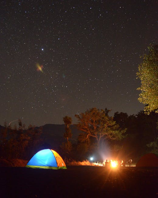
Mathews Arm Campground or Nearby Stay (Evening Option – Paid)
Mathews Arm Campground sits at milepost 22.2, just 1.4 miles from Hogback Overlook. This campground offers 166 sites open from May through October.
Each campsite includes a picnic table and fire ring. The campground has flush toilets, drinking water, and a dump station but no showers.
Campground rates: $30 per night for tent/RV sites
If camping isn’t your style, drive 8 miles to Front Royal for hotel options. The Hampton Inn Front Royal charges around $120 per night and includes breakfast.
Alternative lodging in Front Royal:
- Hampton Inn: $120/night (includes breakfast)
- Quality Inn: $90/night
- Super 8: $75/night
Reservations fill up fast during peak fall season, so book early.
Explore Luray and Luray Caverns (Drive: 25 min / 18 mi – Paid)
From Mathews Arm, drive 18 miles east on Route 211 to reach the town of Luray. This charming valley town offers dining, shopping, and the famous Luray Caverns.
Luray Caverns features the largest caverns in eastern America and holds National Landmark status. The one-hour guided tour takes you through cathedral-sized rooms filled with stalactites and stalagmites.
The highlight is the Stalacpipe Organ, which creates music using the cave’s natural formations. Tours run every 20 minutes year-round.
Luray Caverns Details:
- Hours: 9 AM – 4 PM daily (extended weekend hours)
- Cost: Adults $32, Kids (6-12) $16
- Tour time: 60 minutes
- Temperature: 54°F year-round
After the caves, explore downtown Luray’s restaurants and shops along Main Street. The Mimslyn Inn offers upscale dining, while Gathering Grounds serves casual coffee and sandwiches.
Day 2: Central Skyline Drive, Big Meadows, and Waterfall Hikes
Day two takes you to the heart of Shenandoah at mile 51, where Big Meadows offers rare high-elevation meadows perfect for wildlife viewing. You’ll hike to one of the park’s most popular waterfalls and experience a section of the famous Appalachian Trail.
Big Meadows and Byrd Visitor Center (1.5 hrs – Free & Paid)
Start your morning at Big Meadows around 8:00 AM. This unique high-elevation meadow spans several acres and creates open, rolling landscape unlike anywhere else on Skyline Drive.
The Harry F. Byrd, Sr. Visitor Center serves as your first stop (free entry). The center houses exhibits about the park’s controversial history when mountain families were displaced in the 1930s. You can watch “Shenandoah: The Gift,” a 20-minute film explaining how the park formed.
Wildlife viewing works best at dawn and dusk. White-tailed deer graze openly in the meadows. Black bears often forage along forest edges during early morning hours.
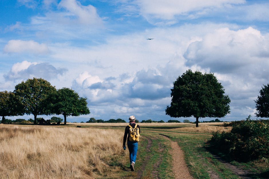
The Story of the Forest Trail offers a 1.8-mile family-friendly loop that starts near the visitor center. This easy walk takes about 45 minutes and shows how forests change over time.
Big Meadows Campground sits adjacent to the meadow if you’re staying overnight. The campground has 221 sites and costs $30 per night during peak season.
Hike to Dark Hollow Falls (1.5 hrs – Free)
Dark Hollow Falls trailhead starts at mile 50.7, just a 2-minute drive from Big Meadows. This 1.4-mile round-trip hike leads to a stunning 70-foot waterfall.
The trail follows Hogcamp Branch downstream through lush forest. Expect a moderate downhill walk for the first half, then a steeper uphill return that requires more effort.
Best viewing times are spring when water flow peaks, or early morning to avoid crowds. The multi-tiered waterfall creates several photo opportunities from different angles.
The trail takes most people 45 minutes down and 45 minutes back up. Proper footwear is essential since rocks can be slippery near the falls.
Swimming is not allowed to protect the delicate ecosystem. Moss-covered rocks, ferns, and wildflowers create a cool microclimate perfect for hot fall days.
Explore Appalachian Trail Segment (1 hr – Free)
Access the Appalachian Trail directly from Big Meadows area. The famous 2,190-mile trail runs parallel to Skyline Drive through most of the park.
Walk north or south from the Big Meadows crossing for an easy 1-2 mile out-and-back experience. The trail here stays relatively flat through mixed hardwood forest.
Fall colors peak in mid-October at this elevation. You might encounter through-hikers tackling the entire trail from Georgia to Maine.
The white blazes on trees mark the official Appalachian Trail route. Side trails with blue blazes connect to other park destinations like Lewis Mountain Campground 10 miles south.
This gives you a taste of America’s most famous hiking trail without major elevation changes or difficult terrain.
Skyland Resort or Big Meadows Lodge for Dining and Relaxation (1-2 hrs – Paid)

End your day with dinner at either Skyland Resort (mile 41.7) or Big Meadows Lodge (mile 51.2). Both offer full-service dining with mountain views.
Skyland Resort sits at the highest point on Skyline Drive at 3,680 feet elevation. The dining room features floor-to-ceiling windows facing the Shenandoah Valley. Dinner entrees range from $18-32, and sunset viewing from the terrace is spectacular.
Big Meadows Lodge provides a more intimate setting right at the meadow’s edge. The restaurant serves regional cuisine with entrees from $16-28. You can often spot deer grazing outside the windows during dinner.
Both locations require reservations during peak fall season (mid-October). If dining rooms are full, both have casual taprooms serving lighter meals and local beers.
Driving time between the two is 15 minutes via Skyline Drive. Skyland offers better sunset views, while Big Meadows provides easier wildlife viewing opportunities after your meal.
Must-See Vistas, Hikes, and Fall Photo Ops
Three spots offer the best views and easiest hikes for fall colors. Each location gives you different angles of the Shenandoah Valley with bright red and orange leaves.
Drive to Hawksbill Summit and Upper Hawksbill Trail (2 hrs – Free)
Hawksbill Summit sits at 4,051 feet, making it the tallest peak in Shenandoah National Park. You can drive most of the way up and only hike 1.1 miles to reach the top.
Getting There:
- Drive to Mile 45.6 on Skyline Drive
- Park at Upper Hawksbill parking area
- 15-minute drive from Luray entrance
The Upper Hawksbill Trail takes about 45 minutes each way. The path is rocky but not too steep. You’ll walk through thick woods filled with maples and oaks that turn bright colors in fall.
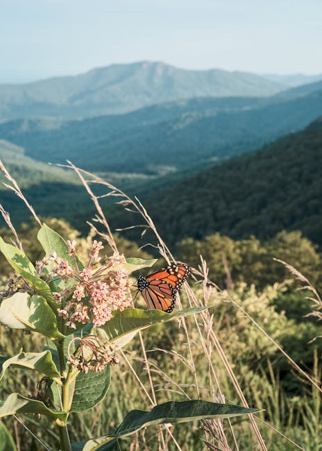
At the summit, you get 360-degree views of the Shenandoah Valley. Look west to see the valley floor spread out below. On clear days, you can spot the Shenandoah River winding through farmland.
Best Photo Spots:
- Rock outcrop at the summit
- Views facing west toward the valley
- Tree tunnels along the trail
The summit gets crowded on weekends. Visit early morning or late afternoon for better lighting and fewer people.
Pinnacles Overlook and Blackrock Summit (1 hr – Free)

Pinnacles Overlook sits at Mile 35.1 on Skyline Drive. You can walk right from your car to the viewing area in 2 minutes. This spot gives you wide views of the valley without any hiking.
The overlook faces west, making it perfect for sunset photos. Fall trees frame the valley view. You’ll see layers of mountains that fade into the distance.
Blackrock Summit requires a short 1-mile loop hike. Drive to Mile 84.8 and park at the Blackrock Summit parking area. The trail takes about 30 minutes to complete.
What Makes It Special:
- Large rock formations to climb on
- Views in all directions
- Easy trail good for families
The rocks at Blackrock Summit are dark and create good contrast with fall colors. You can climb safely on most of the boulders. Kids enjoy scrambling on the rocks while adults take photos.
Both spots offer free parking. No entrance fees beyond the park pass.
Bearfence Mountain Loop for Panoramic Views (1 hr – Free)
The Bearfence Mountain Loop is a 1.2-mile trail that starts at Mile 56.4 on Skyline Drive. This hike takes about 1 hour to finish and includes some rock scrambling.
The trail climbs through oak and hickory trees that turn yellow and brown in fall. About halfway up, you’ll reach exposed rock areas where you need to use your hands to climb.
Trail Details:
- Distance: 1.2 miles
- Time: 45-60 minutes
- Difficulty: Moderate due to rocks
- Elevation gain: 340 feet
The summit offers views of the Shenandoah Valley to the west and Piedmont region to the east. This is one of the few spots where you can see both sides of the mountains clearly.
Wear good shoes with grip. The rocks can be slippery when wet. Bring water even though it’s a short hike.
The loop trail means you don’t backtrack. You’ll see different views and tree types on the way down. Fall colors peak here in mid-October most years.
Weekend Campgrounds and Waysides Along Skyline Drive
Shenandoah National Park offers four campgrounds along the 105-mile Skyline Drive, each with unique features and amenities. Two waysides provide meals and camping supplies during your fall adventure.
Overview of Park Campgrounds (Mathews Arm, Big Meadows, Lewis Mountain, Loft Mountain)
Mathews Arm Campground sits at Mile 22.1 and is closest to Washington DC. It has 164 campsites with no hookups or showers. About 75% of sites are first-come, first-served.
You can park here and hike to Overall Run Falls, the park’s tallest waterfall at 93 feet. The trail is 3.2 miles with a steep 800-foot descent.
Big Meadows Campground at Mile 51 is the largest with over 200 sites. This family-friendly spot offers ranger programs and easy trail access. It’s about two hours from DC.
Lewis Mountain Campground is the smallest and most intimate option. It provides a quieter experience than the larger campgrounds.
Loft Mountain Campground sits in the southern section of the park. It offers great views and access to southern trails and overlooks.
None of the campgrounds have RV hookups. All have dump stations and water spigots throughout. Generators are allowed from 8-10 AM and 4-7 PM only.
Elkwallow and Loft Mountain Waysides for Meals and Essentials (30 min Stops – Paid)

Elkwallow Wayside at Mile 24.1 serves made-to-order sandwiches, soups, and baked goods. You can grab camping supplies and groceries here too. Plan 30 minutes for a meal stop.
The deli operates seasonally from spring through fall. Prices range from $8-15 for sandwiches and meals. You can eat at outdoor picnic tables right next to the store.
Loft Mountain Wayside offers similar services in the southern section of the park. Both waysides close during winter months from late fall to early spring.
These stops are perfect for restocking snacks, drinks, and basic camping gear. You’ll pay convenience store prices, but the locations save you trips outside the park.
Both waysides have clean restrooms and small gift shops. They’re essential stops if you’re camping without a full cooler setup.
Camping Tips and Reservation Advice
Reserve your campsite in advance through Recreation.gov, especially for fall weekends. Big Meadows fills up fastest during peak foliage season in October.
Mathews Arm offers the most first-come, first-served sites if you’re willing to arrive early. Get there before noon on Fridays for the best selection.
Bring cash for firewood and ice. Each campground has these available for purchase. Firewood costs about $5-8 per bundle.
Pack layers for cool mountain nights. Temperatures can drop 20-30 degrees from day to night in fall. Bring a warm sleeping bag rated for 40°F or lower.
Most campsites accommodate tents and RVs up to 35 feet. You’ll need to bring your own water and power for RVs since there are no hookups available.
Extended Fun: Exploring Surrounding Destinations Beyond Skyline Drive
The Shenandoah Valley and Blue Ridge Parkway offer stunning mountain views and historic sites just minutes from Skyline Drive. Waynesboro provides small-town charm with antique shops and local restaurants, while Rapidan Camp shares presidential history from the Hoover era.
Quick Detours: Shenandoah Valley and the Blue Ridge Parkway
The Blue Ridge Parkway connects directly to Skyline Drive at Rockfish Gap. This scenic route stretches 469 miles through the Appalachian Mountains.
You can drive south for 30 minutes to reach beautiful overlooks like Humpback Rocks. The visitor center there is free to explore and offers great views.
Popular Blue Ridge Parkway Stops:
- Humpback Rocks (15 min drive from Skyline Drive – Free)
- Crabtree Falls (45 min drive – Free parking, moderate 2.9-mile hike)
- Natural Bridge State Park (1 hour drive – $8 admission)
The Shenandoah Valley floor offers farm tours and wineries. Most wineries charge $5-15 for tastings. Apple orchards like Graves Mountain Farm welcome visitors during fall harvest season.
Plan 2-3 hours for each Blue Ridge Parkway stop. Gas stations are limited, so fill up before heading out.
Visit to Downtown Waynesboro (Drive: 45 min / 35 mi – Free & Paid Options)
Waynesboro sits at the southern end of Shenandoah National Park. This small city offers antique shopping, local restaurants, and easy access to outdoor activities.
Free Activities in Waynesboro:
- Walk the South River Greenway Trail (2.4 miles, paved)
- Browse downtown shops and galleries
- Visit the Waynesboro Heritage Museum (free admission)
Paid Activities:
- Dinner at local restaurants ($15-25 per person)
- Antique shopping at various stores
- Mini golf at Fun Land ($8 per person)
The South River flows right through downtown. You can fish there for free with a Virginia fishing license ($23 for non-residents).
Plan 3-4 hours total for Waynesboro. The drive takes about 45 minutes from central Skyline Drive locations. Main Street has free parking and easy walking access to most attractions.
Historic Sites: Rapidan Camp (1 hr – Guided Tour or Self-Guided – Free & Paid)
Rapidan Camp served as President Herbert Hoover’s retreat from 1929 to 1932. The camp sits along the Rapidan River in a peaceful mountain setting.
You can reach the camp by hiking the Mill Prong Trail. This moderate 4.2-mile round trip takes about 2.5 hours total. The trail is free to access.
What You’ll See:
- President Hoover’s cabin (restored)
- The Brown House (guest quarters)
- Stone fireplaces and camp buildings
- Beautiful river views
Self-guided tours are always free. Pick up a brochure at any visitor center. Guided tours run on weekends during peak season for $5 per adult.
The drive to the trailhead takes about 30 minutes from Skyline Drive. Park at the Milam Gap parking area (mile marker 52.8). Bring water and snacks since no facilities exist at the camp itself.
* Prices are as of 2025 and are subject to change.


