

Finding your way outdoors is easier than ever, thanks to the many hiking and navigation apps available now. With the right app, you can plan new routes, stay safe, and make your hikes more enjoyable. The best hiking apps for navigation include AllTrails, Gaia GPS, and Komoot, which let you download maps, track your location offline, and discover new trails.
No matter your experience level—beginner or seasoned hiker—these top-rated apps are great tools for staying on track. With features that range from basic trail browsing to detailed GPS tracking, they make it easy to find the right option to match your needs and hiking goals.
Choosing the right app can make a big difference in your hiking experience. You can use them to get detailed trail information, share your hikes, or even find hidden paths that aren’t in guidebooks.
Top-Rated Hiking and Navigation Apps

The right hiking app can make a big difference in how you plan, follow, and enjoy your outdoor adventures. Popular apps vary in the types of maps they offer, how you find trails, and their support for offline navigation.
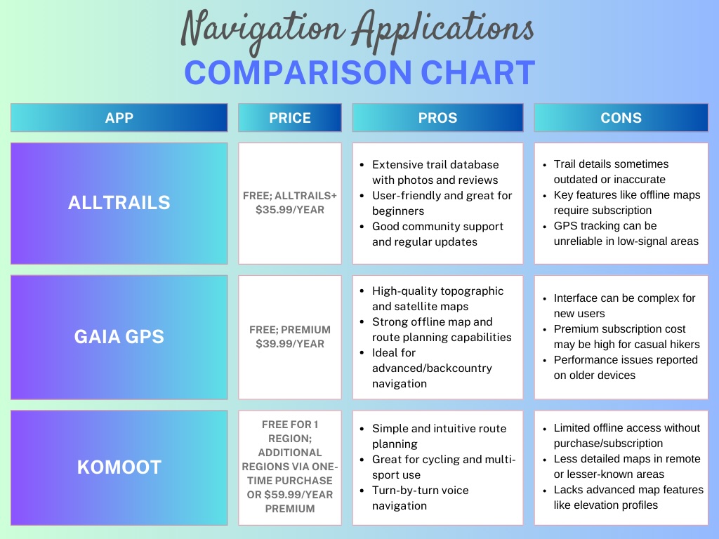
1. AllTrails Features and Usability
AllTrails is one of the most well-known hiking apps for finding trails quickly. Its large database includes detailed maps, user reviews, and photos. You can search for routes based on difficulty, length, and nearby features.
The app offers a simple, clear interface. After choosing a hike, you see an overview with stats like distance, elevation, and trail type. Navigating a route is made easier by turn-by-turn directions and GPS tracking. A community section lets you log hikes, share experiences, and ask questions.
In addition, AllTrails is especially helpful for dog owners and families alike, as many users include detailed notes and reviews about whether a trail is dog-friendly and family-friendly. You can easily filter trails by options like dog-friendly, family-friendly, and even ID (service dog) friendly. The community often shares useful info such as leash requirements, trail difficulty, water availability, and how suitable the path is for kids or strollers.

While AllTrails has received mixed reviews from hikers—mainly due to occasional inaccuracies in trail information, outdated reviews, or discrepancies in trail difficulty ratings—it remains my go-to hiking app. One of its most valuable features is the ability to download trail maps ahead of time through its subscription service, which costs just $35.99 a year.
Editor’s Experience: This feature proved essential during a recent trip to Joshua Tree National Park, where cell service is virtually nonexistent once you enter. We arrived at the park around 6 a.m.—well before any park rangers were available to hand out physical maps. Fortunately, I had already downloaded the trails we planned to hike, along with the full map of the park, directly onto my phone. With AllTrails, we could easily navigate not only the trailheads but also the main park roads. The app provides GPS-based guidance, elevation profiles, and user reviews, making it incredibly helpful for planning hikes and staying on course—even in the most remote areas.
2. Gaia GPS for Advanced Navigation

Gaia GPS stands out for in-depth mapping and navigation. You gain access to a wide range of detailed map layers, including topographic, satellite, and public land boundaries. These map types are helpful for backcountry travelers and those who enjoy off-trail exploration.
The app supports custom waypoints, route plotting, and importing or exporting GPX files. Gaia GPS gives you tools to track your hike in real time, measure distances, and view elevation profiles.
Advanced users can overlay multiple map layers at once, such as seeing trails on top of hunting boundaries or wildfire history. Offline map access is available with a premium subscription, supporting navigation in areas without cell service.
While Gaia GPS is popular for its in-depth maps and robust tracking features, it’s not without its downsides. One of the main drawbacks is its user interface, which can be complex and intimidating for beginners. Unlike more intuitive apps, Gaia GPS often requires a bit of a learning curve to fully understand and use its features effectively. Many of its most valuable tools—such as offline maps, weather overlays, and specialized map layers—are only available with a premium subscription, which costs $39.99 per year. Some users have noted occasional performance issues, such as lag or bugs on older smartphones, and inconsistent syncing between devices.

3. Komoot for Trail Discovery
Komoot offers a different approach by focusing on route planning and discovery. The app recommends hiking trails, biking paths, and running routes based on your fitness level and interests. Step-by-step voice navigation keeps you on track during your hike.
You can customize your planned adventure by choosing surface type, waypoints, and route distance. Komoot suggests highlights like viewpoints, lakes, and picnic areas along your path. The app’s built-in offline mode ensures your routes are available without internet access.
Komoot is also social. You can connect with other users, share completed trails, and read reviews. The app’s blend of discovery and navigation tools makes it a strong pick for those exploring new places.
Komoot is a solid choice for route planning, especially for cyclists and casual hikers, but it has a few downsides. Trail coverage in remote or less-traveled areas can be limited, and the app doesn’t always provide real-time updates on trail conditions or closures. While one region is free, accessing offline maps for additional areas requires either individual purchases or a $59.99/year premium subscription, which may not be ideal for users who hike in multiple locations. Komoot also lacks advanced features like topographic maps, weather overlays, and detailed elevation data that more experienced outdoor enthusiasts often rely on.

Essential App Functions for Hikers
Hiking apps should make your trips safer, easier, and more enjoyable. Choosing the right app comes down to which features help you plan, track, and stay informed during your hike.
Offline Maps and Download Options
Reliable hiking apps give you access to maps even when you lose cell service. Many popular apps let you download topographic, satellite, and trail maps for offline use. This is important in remote areas where you might not have a signal.
With offline maps, you can check your route, see nearby trails, and find your location using GPS alone. Look for options where you can choose the type of map to download, such as terrain or road maps, depending on your needs.
Some apps, like Gaia GPS and OS Maps, allow you to save maps at different zoom levels, so you can see both the big picture and key trail details. This feature is often part of a paid plan but sometimes available for free. Checking storage space before downloading large map files is also a good idea.
Live Location Tracking

A good hiking app tracks your location in real time with GPS. You can see your position on the map and follow your progress along a planned route. If you wander off the trail, the app can help guide you back.
Live location tracking also lets you share your location with friends or family for safety. Some apps even allow group tracking so everyone knows where the group is at any time. This is useful for staying together when hiking with others or if you need help.
Common tracking features include distance walked, elevation gain, average speed, and estimated time to finish. Live tracking means you don’t have to stop and check a paper map or guess where you are. This makes your hikes more relaxed and helps prevent you from getting lost.
Trail Information and User Reviews

You can find detailed info about thousands of hiking trails in many hiking apps. This includes trail length, difficulty, elevation, and features like lakes or viewpoints. Some apps show if dogs or bikes are allowed.
User reviews are one of the most helpful features. Hikers share updates on trail conditions, obstacles, and tips for your trip. This feedback is especially valuable after storms, during muddy seasons, or when planning long hikes.
Finding trails with good reviews and recent updates is easier with apps like AllTrails, which offer large communities of users posting honest experiences. You can also see star ratings, photos, and even warnings about closed paths or dangerous sections, helping you plan smarter and stay safe.
Choosing the Best App for Your Needs
Compatibility with Wearables and Devices
Before picking an app, check if it works with your smartphone, GPS device, or smartwatch. Some apps are limited to iOS or Android, while others also work on Apple Watch or Garmin devices.
AllTrails and Gaia GPS have apps for both iOS and Android, ensuring most users are covered. AllTrails can send trail navigation to an Apple Watch. Gaia GPS offers smartwatch support too, making it easier to check your progress without taking out your phone. Komoot’s key benefits is its ability to send detailed trail navigation directly to your device, making it easy to stay on course during your outdoor adventures. Whether you’re hiking, biking, or trail running, Komoot provides turn-by-turn navigation with voice prompts or visual guidance, helping you follow the exact path you planned. This reduces the need to constantly check your phone and lowers the chance of getting lost
If you use Garmin or Suunto watches, check for direct syncing. Some apps can send routes to your wearable and track your stats in real time. This helps when tracking distance, elevation, and pace hands-free.
For people with older phones or off-brand devices, some features may not work as well. Always check the latest compatibility details listed on the app website or app store page.
Safety and Emergency Features

Safety features in hiking apps should not be ignored, especially if you hike alone or go off the beaten path. Some apps have “live tracking,” which lets family or friends see your location in real time.
Gaia GPS and AllTrails both let you download offline maps. This is important if you lose phone signal. Some apps let you set up emergency contacts, who will be alerted if you stop moving or leave a set route. Komoot’s offline features make outdoor adventures safer and more convenient. You can navigate trails and routes without cell service, making it perfect for remote hikes or bike rides. Offline maps save battery and data, while voice-guided directions still work to keep you on track. You can download regions in advance and access trail info, elevation profiles, and surface types even when you’re completely off the grid—ideal for planning ahead and staying prepared wherever you go.
Avenza Maps is known for allowing users to access maps offline and mark GPS coordinates. This feature can help rescue teams find you faster if you get lost. Certain apps also show weather alerts, road closures, and fire warnings. These small details can improve your safety and planning.
Make sure the app you choose supports offline access and lets you share your hike plans with someone you trust.
Prices are as of May 2025 & are subject to change.


